Yakushima
World Heritage
Japan
🎧 Listen to Introduction
Located inland from Yakushima Island, Yakushima is located at the intersection of the Palearctic and Oriental bioregions and is rich in plant species, with approximately 1,900 species and subspecies, including ancient specimens of Japanese cedar trees. In addition, there are remnants of warm temperate old-growth forests that are unique in the region.
# Plant species
# Palearctic
# Oriental World
# Bioregional Confluence
# Japanese cedar
# Warm temperate zone
.jpg)
.jpg)
Poem of the heritage generated by AI
Intangible culture related to the heritage
China tourist attractions related to the heritage
World heritage related to the heritage
Show more related heritage
Information extracted from Wikidata
| uses | 4311745-4 |
| image | http://commons.wikimedia.org/wiki/Special:FilePath/Yakushima%20from%20Ferry%20Amami%2020121116.jpg |
| instance of | island |
| locator map image | http://commons.wikimedia.org/wiki/Special:FilePath/Japan%20satellite%20view%20with%20Yakushima%20tagged.png |
| executive body | Yakushima |
| location of creation | 屋久島 |
| U.S. National Archives Identifier | 10036957 |
| number of rooms | viaf-257266771 |
| office held by head of the organization | http://g.co/kg/m/01h4jn |
| Commons category | Yakushima |
| located in time zone | UTC+09:00 |
| highest point | Mount Miyanoura |
| coordinate location | Point(130.5 30.33333) |
| coordinate location | Point(130.528611111 30.358611111) |
| Commons gallery | 屋久島 |
| page banner | http://commons.wikimedia.org/wiki/Special:FilePath/Yakushima%20banner.jpg |
| page banner | http://commons.wikimedia.org/wiki/Special:FilePath/Forest%20in%20Yakushima%2080%20%28cropped%29.jpg |
| U.S. National Archives Identifier | 10036957 |
| time of earliest written record | 0607-01-01T00:00:00Z |
| heritage designation | Ramsar site |
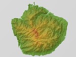
| relief location map | http://commons.wikimedia.org/wiki/Special:FilePath/Yakushima%20Relief%20Map%2C%20SRTM.jpg |
| length | 28.3 |
| elevation above sea level | 1935 |
| area | 10747 |
| area | 504.29 |
| width | 25.7 |
| UNESCO Biosphere Reserve URL | http://www.unesco.org/mabdb/br/brdir/directory/biores.asp?code=JPN+04&mode=all |
| perimeter | 132 |
| population | 13178 |
| point in time | 2010-01-01T00:00:00Z |
| start time | 1993-01-01T00:00:00Z |
| official name | 屋久島 |
| official name | ياكوشيما |
| official name | Yakushima |
| official name | Yakushima |
| official name | Yakushima |
| official name | Yakushima |
| official name | Остров Якусима |
| official name | 屋久岛 |