Samarra Archaeological City
World Heritage
Iraq
🎧 Listen to Introduction
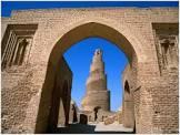
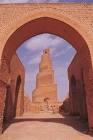
The archaeological city of Samarra was a powerful Islamic capital that ruled for a century from the Abbasid provinces stretching from Tunisia to Central Asia. Located 130 km north of Baghdad on the banks of the Tigris River, the site is 41.5 km long from north to south and varies in width from 8 km to 4 km. It bears witness to the architectural and artistic innovations that developed there and spread to the rest of the Islamic world and beyond. The 9th-century Great Mosque and its spiral minaret are among the site's many striking architectural monuments, 80% of which have yet to be excavated.
# Tigris River
# Islamic capital
# Abbasid Dynasty
# Innovation in architecture and art
# 9th century Great Mosque
# Spiral spire


Poem of the heritage generated by AI
Intangible culture related to the heritage
China tourist attractions related to the heritage
World heritage related to the heritage
Show more related heritage
Information extracted from Wikidata
| World Heritage criteria | World Heritage selection criterion (ii) |
| World Heritage criteria | Larousse Encyclopedia online |
| category for maps | Category:Maps of Samarra |
| location of creation | سامراء |
| U.S. National Archives Identifier | 10044312 |
| male population | 1236860 |
| IPA transcription | 3530182 |
| number of rooms | lccn-n86116843 |
| office held by head of the organization | http://g.co/kg/m/01clrh |
| postal code | 34010 |
| Commons category | Samarra |
| has part | al-Ma'shuq |
| has part | al-Istablat |
| has part | Samarra South Zone |
| has part | al-Huwaysilat Lower |
| has part | EC-HH-19/C-2011 |
| has part | Qubbat al-Sulaibiyya |
| has part | Tell Umm al-Sakhr |
| has part | al-Quwayr |
| has part | Samarra Centre Zone |
| coordinate location | Point(43.88568 34.1959) |
| start time | 2007-01-01T00:00:00Z |
| topic's main category | Category:Samarra |
| Commons gallery | سامراء |
| page banner | http://commons.wikimedia.org/wiki/Special:FilePath/Samarra%20spiral%20minaret%20wikivoyage%20banner.jpg |
| U.S. National Archives Identifier | 10044312 |
| native label | سامراء |
| category of associated people | Category:People from Samarra |
| elevation above sea level | 80 |
| area | 15058 |
| area | 150.58 |
| uses | 4105268-7 |
| instance of | big city |
| located in the administrative territorial entity | Saladin Governorate |
| executive body | Samarra |
| pronunciation audio | http://commons.wikimedia.org/wiki/Special:FilePath/LL-Q13955%20%28ara%29-Spotless%20Mind1988-%D8%B3%D8%A7%D9%85%D8%B1%D8%A7%D8%A1.wav |
| language of work or name | Prague 14 |
| pronunciation audio | http://commons.wikimedia.org/wiki/Special:FilePath/LL-Q13955%20%28ara%29-Zinou2go-%D8%B3%D8%A7%D9%85%D8%B1%D8%A7%D8%A1.wav |
| language of work or name | Prague 14 |
| population | 140400 |
| point in time | 2015-01-01T00:00:00Z |
| population | 201700 |
| point in time | 2002-01-01T00:00:00Z |
| population | 348700 |
| point in time | 2003-01-01T00:00:00Z |
| start time | 2007-01-01T00:00:00Z |
| official name | مدينة سامراء الأثرية |
| official name | Samarra Archaeological City |
| official name | Ciudad arqueológica de Samarra |
| official name | Ville archéologique de Samarra |
| official name | 都市遺跡サーマッラー |
| official name | Archeologische stad Samarra |
| official name | Археологический памятник Самарра |
| official name | 萨迈拉古城 |
| volume as quantity | World Heritage selection criterion (ii) |
| volume as quantity | Larousse Encyclopedia online |
| area | 31414 |
| applies to part | buffer zone |
| image | http://commons.wikimedia.org/wiki/Special:FilePath/The%20spiral%20minaret%20in%20Samarra.jpg |
| media legend | Spirálovitý minaret Velké mešity z poloviny 9. století |
| media legend | Mosg Mawr Samarra |
| media legend | A híres spirál-minaret |