Purnululu National Park
World Heritage
Australia
🎧 Listen to Introduction
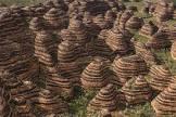
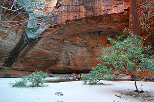
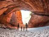
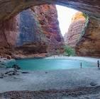
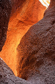
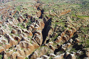
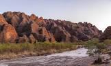
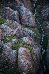
Purnuluru National Park covers an area of 239,723 hectares and is located in Western Australia. The park contains the Bungle Bungle Range, which consists of quartz sandstone of the Devonian period, which has been eroded over 20 million years to form a series of honeycomb-like towers or cones, whose steep slopes are clearly marked by regular horizontal bands of dark grey cyanobacterial shells (single-celled photosynthetic organisms). These cones are outstanding examples of karst, and their existence and uniqueness are due to a variety of interacting geological, biological, erosional and climatic phenomena.
# Western Australia
# Bungle Bungle Range
# Quartz sandstone
# Honeycomb Tower
# Cyanobacteria shell
# Conical karst

Poem of the heritage generated by AI
Intangible culture related to the heritage
China tourist attractions related to the heritage
World heritage related to the heritage
Show more related heritage
Information extracted from Wikidata
| office held by head of the organization | http://g.co/kg/m/0pwl8 |
| Commons category | Purnululu National Park |
| inception | 1987-01-01T00:00:00Z |
| coordinate location | Point(128.564166666 -17.463055555) |
| official website | http://parks.dpaw.wa.gov.au/park/purnululu |
| page banner | http://commons.wikimedia.org/wiki/Special:FilePath/Purnululu%20WV%20banner.jpg |
| native label | Purnululu National Park |
| elevation above sea level | 287 |
| area | 2397 |
| area | 239723 |
| area | 2438.30875 |
| country | Wet Tropics of Queensland - Component around Edmund Kennedy |
| image | http://commons.wikimedia.org/wiki/Special:FilePath/Purnululu%20National%20Park%20DSC03767.jpg |
| instance of | Nîmes |
| located in the administrative territorial entity | Shire of Halls Creek |
| operator | Department of Parks and Wildlife |
| executive body | Purnululu National Park |
| population | 15 |
| determination method | Australian census 2016 |
| applies to part | state suburb |
| point in time | 2016-08-09T00:00:00Z |
| start time | 2003-01-01T00:00:00Z |
| official name | منتزه بورنولولو الوطني |
| official name | Purnululu National Park |
| official name | Parque Nacional de Purnululu |
| official name | Parc national de Purnululu |
| official name | パーヌルル国立公園 |
| official name | Nationaal Park Purnululu |
| official name | Национальный парк Пурнулулу |
| official name | 波奴鲁鲁国家公园 |
| female population | 8 |
| determination method | Australian census 2016 |
| applies to part | state suburb |
| point in time | 2016-08-09T00:00:00Z |
| male population | 10 |
| determination method | Australian census 2016 |
| applies to part | state suburb |
| point in time | 2016-08-09T00:00:00Z |
| area | 79602 |
| applies to part | buffer zone |
| significant place | Halls Creek |
| object has role | Eliza Fraser |