Pontcysyllte Aqueduct and Canal
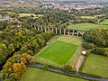
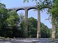
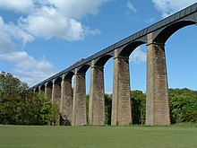
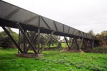
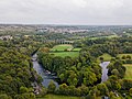
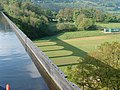
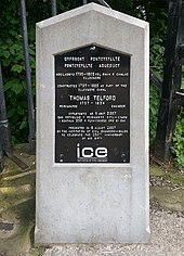
The Pontkistheaster Aqueduct and Canal, located in northeast Wales, is an 18 km long feat of civil engineering during the Industrial Revolution, completed in the early 19th century. The complex geography of the canal required a number of daring civil engineering solutions, not least because it was built without the use of locks. A pioneering masterpiece of engineering and monumental metal architecture, the aqueduct was designed by the renowned civil engineer Thomas Telford. The use of both cast and wrought iron allowed the construction of arches that were both lightweight and strong, and the overall effect is both magnificent and elegant. The site is listed as a masterpiece of creative genius and an extraordinary synthesis of established European expertise. It is also considered an innovative whole that has inspired many projects around the world.
.jpg)


Poem of the heritage generated by AI
Intangible culture related to the heritage
China tourist attractions related to the heritage
World heritage related to the heritage
Information extracted from Wikidata
| ELSTAT geographical code | pontcysyllte-aqueduct |
| number of rooms | lccn-no2014154470 |
| office held by head of the organization | http://g.co/kg/m/025748 |
| Commons category | Pontcysyllte Aqueduct |
| start time | 1805-11-26T00:00:00Z |
| coordinate location | Point(-3.08782 52.9702) |
| official website | http://www.pontcysyllte-aqueduct.co.uk/ |
| number of spans | 18 |
| date of official opening | 1805-01-01T00:00:00Z |
| commemorative plaque image | http://commons.wikimedia.org/wiki/Special:FilePath/Pontcysyllte%20Aqueduct%20Plaque%20-%20geograph.org.uk%20-%201481992.jpg |
| commemorative plaque image | http://commons.wikimedia.org/wiki/Special:FilePath/Pontcysyllte%20aqueduct%20plaque.jpg |
| commemorative plaque image | http://commons.wikimedia.org/wiki/Special:FilePath/Pontcysyllte%20Aqueduct%20%28Transport%20Trust%29.jpg |
| elevation above sea level | 63.6 |
| named as | Pont Cysylltan, Denbighshire |
| Atlas Obscura identifier | pontcysyllte-aqueduct |
| image | http://commons.wikimedia.org/wiki/Special:FilePath/Pontcysyllte%20aqueduct%20arp.jpg |
| located in the administrative territorial entity | Llangollen Rural |
| applies to part | superstructure |
| made from material | Category:Castle in Malbork |
| executive body | Pontcysyllte Aqueduct |