Kuk Early Agricultural Site
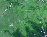
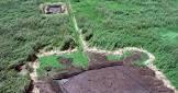
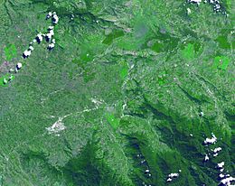
The Cook Early Agricultural Site is located in the western highlands of New Guinea at an altitude of 1,500 meters and covers an area of 116 hectares. Archaeological excavations have shown that the feature is one of wetland reclamation, which was carried out almost continuously for 7,000 years and possibly as long as 10,000 years. The well-preserved archaeological remains at the site show the technological leap from plant exploitation to agriculture about 6,500 years ago. It is an excellent example of how agricultural practices have changed over time, from cultivating mounds to digging trenches with wooden tools to drain wetlands. Cook is one of the few places in the world with archaeological evidence of agriculture developing independently and agricultural practices changing over such a long period of time.


Poem of the heritage generated by AI
Intangible culture related to the heritage
China tourist attractions related to the heritage
World heritage related to the heritage
Information extracted from Wikidata
| country | Papua New Guinea |
| image | http://commons.wikimedia.org/wiki/Special:FilePath/Kuk%20New%20Guinea%202002.jpg |
| located in the administrative territorial entity | Western Highlands Province |
| office held by head of the organization | http://g.co/kg/m/025w7vq |
| coordinate location | Point(144.331722222 -5.783711111) |
| native label | Kuk Swamp |
| area | 116 |
| World Heritage criteria | Larousse Encyclopedia online |
| start time | 2008-01-01T00:00:00Z |
| official name | موقع كوك الزراعي البدائي |
| official name | Kuk Early Agricultural Site |
| official name | Antiguo sitio agrícola de Kuk |
| official name | Ancien site agricole de Kuk |
| official name | クックの初期農耕遺跡 |
| official name | Vroeg agrarisch gebied Kuk |
| official name | Древнее земледельческое поселение Кука |
| volume as quantity | Larousse Encyclopedia online |
| area | 195 |
| applies to part | buffer zone |