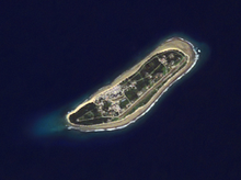
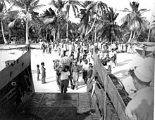
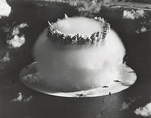
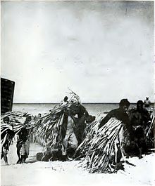
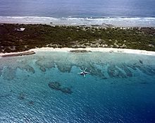
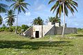
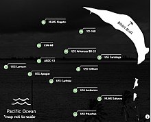
After the Second World War, the United States decided to resume nuclear testing at Bikini Atoll in the Marshall Islands in the Pacific, a move that was closely linked to the beginning of the Cold War. The local population was forcibly displaced, and from 1946 to 1958, the United States conducted 67 nuclear tests, including the explosion of the first hydrogen bomb (1952). Bikini Atoll preserves direct tangible evidence that is important in conveying the power of nuclear tests, namely the shipwrecks that sank to the bottom of the lagoon during the 1946 tests and the huge Bravo Crater. These tests, with a power equivalent to 7,000 times that of the atomic bomb dropped on Hiroshima, had a significant impact on the geology and natural environment of Bikini Atoll and on the health of those exposed to radiation. Although the atoll gives a paradoxical impression of peace and paradise on earth, historically it symbolizes the advent of the nuclear age. This is the first site in the Marshall Islands to be inscribed on the World Heritage List.
| Commons category |
Bikini Atoll |
| coordinate location |
Point(165.383333333 11.583333333) |
| FIPS 6-4 (US counties) |
68070 |
| topic's main category |
Category:Bikini Atoll |
| U.S. National Archives Identifier |
10037080 |
| native label |
Bikini |
| elevation above sea level |
25 |
| area |
6 |
| area |
73500 |
| World Heritage criteria |
Larousse Encyclopedia online |
| World Heritage criteria |
World Heritage selection criterion (vi) |
| Atlas Obscura identifier |
bikini-atoll |
| uses |
4006564-9 |
| image |
http://commons.wikimedia.org/wiki/Special:FilePath/Bikini%20Atoll%202001-01-14%2C%20Landsat%207%20ETM%2B%2C%20bands%203-2-1-8.png |
| instance of |
atoll |
| flag image |
http://commons.wikimedia.org/wiki/Special:FilePath/Flag%20of%20Bikini%20Atoll.svg |
| twinned administrative body |
Keelung |
| locator map image |
http://commons.wikimedia.org/wiki/Special:FilePath/MH%20-map%20A.png |
| executive body |
Bikini Atoll |
| U.S. National Archives Identifier |
10037080 |
| IPA transcription |
1866005 |
| ELSTAT geographical code |
bikini-atoll |
| number of rooms |
viaf-315126982 |
| topographic prominence |
7598 |
| office held by head of the organization |
http://g.co/kg/m/01d6s9 |
| population |
13 |
| point in time |
1999-01-01T00:00:00Z |
| population |
9 |
| point in time |
2011-01-01T00:00:00Z |
| start time |
2010-01-01T00:00:00Z |
| official name |
أتول بيكيني، موقع تجارب نووية |
| official name |
Bikini Atoll Nuclear Test Site |
| official name |
Atolón de Bikini |
| official name |
Site d’essais nucléaires de l’atoll de Bikini |
| official name |
ビキニ環礁核実験場 |
| official name |
Nucleair testcentrum Bikini atol |
| official name |
Атолл Бикини |
| official name |
比基尼环礁核试验地 |
| area |
130425 |
| applies to part |
buffer zone |
| language of work or name |
English |
| named as |
Bikini Atoll |