Vredefort Dome
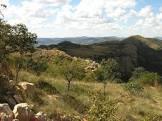
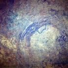
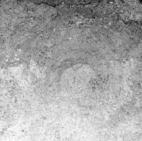
Located approximately 120 km southwest of Johannesburg, the Vreedefort Dome is a representative section of a large meteorite impact structure (or crater). Dating back to 2.023 billion years ago, it is the oldest crater ever discovered on Earth. With a radius of 190 km, it is also the largest and most deeply eroded. The Vreedefort Dome witnessed the world's largest known single energy release event, which had devastating effects around the globe, including, according to some scientists, major evolutionary changes. It provides key evidence for the Earth's geological history and is essential for understanding the evolution of the Earth. Despite the importance of impact sites to Earth history, geological activity on the Earth's surface has caused evidence for most impact sites to disappear, with Vreedefort being the only example that provides a complete geological section of a star-shaped crater below the crater floor.
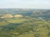


 to SW (right) cross-section through the 2.020-billion-year-old Vr.png)
Poem of the heritage generated by AI
Intangible culture related to the heritage
China tourist attractions related to the heritage
World heritage related to the heritage
Information extracted from Wikidata
| executive body | Vredefort Dome |
| location of creation | Vredefort |
| office held by head of the organization | http://g.co/kg/m/03bvtz |
| Commons category | Vredefort Dome |
| has part | Chocolate tablet breccia site |
| has part | Stromatolite/basal fault plane site |
| time of discovery or invention | 1937-01-01T00:00:00Z |
| coordinate location | Point(27.416666666 -26.816666666) |
| coordinate location | Point(27.5 -27.0) |
| topic's main category | Priolo Gargallo |
| Commons gallery | Vredefort |
| area | 30000 |
| diameter | 300 |
| image | http://commons.wikimedia.org/wiki/Special:FilePath/Vredefort%20Dome%20STS51I-33-56AA.jpg |
| located in the administrative territorial entity | Free State |
| start time | 2005-01-01T00:00:00Z |
| official name | قبة فريدفورت |
| official name | Vredefort Dome |
| official name | Bóveda de Vredefort |
| official name | Dôme de Vredefort |
| official name | フレーデフォート・ドーム |
| official name | Vredefortkrater |
| official name | Астроблема Вредефорт |
| official name | 弗里德堡陨石坑 |