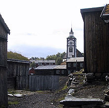
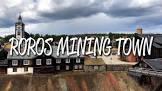
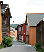
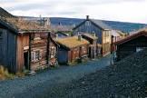
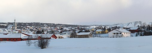
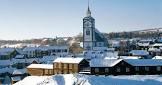
The mining town of Røros and the surrounding area are associated with copper mining, which began in the 17th century and was worked for 333 years until 1977. The site includes the town and its industrial rural cultural landscape, the smelter Femundshytta and its associated areas, and winter transport routes. Røros was destroyed by Swedish troops in 1679 and has since been completely rebuilt, with around 2,000 one- and two-storey wooden houses and a smelter. Many of the buildings retain their black wooden façades, giving the town a medieval appearance. The site is surrounded by a buffer zone that coincides with the privileged zone (periphery) granted to mining companies by the Danish-Norwegian Crown (1646), demonstrating a lasting culture based on copper mining that was established and flourished in a remote, climatically harsh region.
| significant event |
boundary change |
| point in time |
1989-04-21T00:00:00Z |
| significant event |
boundary change |
| point in time |
1875-01-01T00:00:00Z |
| significant event |
boundary change |
| point in time |
2020-03-01T00:00:00Z |
| population |
5581 |
| determination method |
National Population Register |
| point in time |
2020-01-01T00:00:00Z |
| population |
5635 |
| determination method |
census |
| point in time |
2016-01-01T00:00:00Z |
| replaces |
Røros landsogn |
| point in time |
1964-01-01T00:00:00Z |
| replaced by |
Røros landsogn |
| point in time |
1926-01-01T00:00:00Z |
| number of households |
11 |
| applies to part |
apartment building |
| point in time |
2018-01-01T00:00:00Z |
| number of households |
72 |
| applies to part |
statistic residue |
| point in time |
2018-01-01T00:00:00Z |
| number of households |
1939 |
| point in time |
2018-01-01T00:00:00Z |
| number of households |
308 |
| applies to part |
semi-detached home |
| point in time |
2018-01-01T00:00:00Z |
| number of households |
2647 |
| applies to part |
statistic sum |
| point in time |
2018-01-01T00:00:00Z |
| number of households |
317 |
| applies to part |
terrace house |
| point in time |
2018-01-01T00:00:00Z |
| area |
1956.46 |
| applies to part |
whole |
| point in time |
2020-01-01T00:00:00Z |
| area |
843.79 |
| point in time |
2020-01-01T00:00:00Z |
| area |
0 |
| applies to part |
territorial waters |
| point in time |
2018-01-18T00:00:00Z |
| area |
689.1711465610532 |
| applies to part |
open area |
| point in time |
2018-01-18T00:00:00Z |
| area |
0.9963786016469645 |
| applies to part |
other |
| point in time |
2018-01-18T00:00:00Z |
| area |
5.42 |
| applies to part |
arroyo |
| point in time |
2020-01-01T00:00:00Z |
| area |
27.38 |
| applies to part |
arable land |
| point in time |
2020-01-01T00:00:00Z |
| area |
807.8032568951182 |
| point in time |
2018-01-18T00:00:00Z |
| area |
228.61777091735507 |
| applies to part |
bog |
| point in time |
2018-01-18T00:00:00Z |
| area |
5.504600722010724 |
| applies to part |
arroyo |
| point in time |
2018-01-18T00:00:00Z |
| area |
27.356692047890892 |
| applies to part |
arable land |
| point in time |
2018-01-18T00:00:00Z |
| area |
194.7422133167747 |
| applies to part |
lake |
| point in time |
2018-01-18T00:00:00Z |
| area |
1.09 |
| applies to part |
other |
| point in time |
2020-01-01T00:00:00Z |
| area |
2.02 |
| applies to part |
urban agglomeration |
| point in time |
2020-01-01T00:00:00Z |
| area |
1956.4580976522377 |
| applies to part |
island |
| applies to part |
landmass |
| point in time |
2018-01-18T00:00:00Z |
| area |
0 |
| applies to part |
snow |
| applies to part |
ice |
| applies to part |
glacier |
| point in time |
2018-01-18T00:00:00Z |
| area |
662.22 |
| applies to part |
open area |
| point in time |
2020-01-01T00:00:00Z |
| area |
1956.46 |
| applies to part |
island |
| applies to part |
landmass |
| point in time |
2020-01-01T00:00:00Z |
| area |
194.67 |
| applies to part |
lake |
| point in time |
2020-01-01T00:00:00Z |
| area |
0.26 |
| applies to part |
Biertan fortified church |
| point in time |
2020-01-01T00:00:00Z |
| area |
0.2565625463145276 |
| applies to part |
Biertan fortified church |
| point in time |
2018-01-18T00:00:00Z |
| area |
2.0094760440733337 |
| applies to part |
urban agglomeration |
| point in time |
2018-01-18T00:00:00Z |
| area |
0 |
| applies to part |
snow |
| applies to part |
ice |
| applies to part |
glacier |
| point in time |
2020-01-01T00:00:00Z |
| area |
1956.4580976522377 |
| applies to part |
whole |
| point in time |
2018-01-18T00:00:00Z |
| area |
219.63 |
| applies to part |
bog |
| point in time |
2020-01-01T00:00:00Z |
| Norwegian municipality number |
1640 |
| end time |
2017-12-31T00:00:00Z |
| Norwegian municipality number |
5025 |
| start time |
2018-01-01T00:00:00Z |
| point in time |
2015-10-01T00:00:00Z |
| object has role |
målform |
| point in time |
2015-10-01T00:00:00Z |
| object has role |
målform |
| member of political party |
Norwegian Labour Party |
| start time |
2019-01-01T00:00:00Z |
| head of government |
Hans Vintervold |
| start time |
2007-01-01T00:00:00Z |
| end time |
2019-01-01T00:00:00Z |
| located in the administrative territorial entity |
Trøndelag |
| start time |
2018-01-01T00:00:00Z |
| located in the administrative territorial entity |
Sør-Trøndelag |
| end time |
2017-12-31T00:00:00Z |
.jpg)

.jpg)