Monumental Earthworks of Poverty Point
World Heritage
USA
🎧 Listen to Introduction
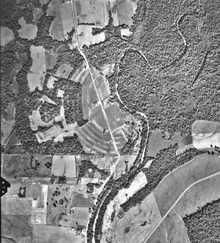
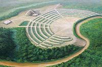
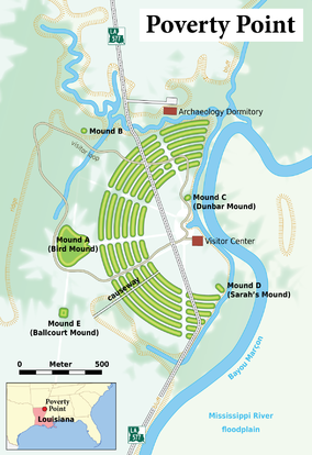
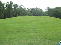
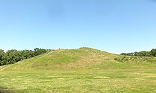
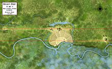
The Poverty Point Monumental Works are named for the 19th-century plantation adjacent to the site, which is located on slightly elevated, narrow terrain in the lower Mississippi River valley. The complex consists of five mounds, six concentric semi-elliptical ridges separated by shallow depressions, and a central plaza. It was built by a group of hunter-gatherers for residential and ceremonial purposes between 3,700 and 3,100 years ago. It is a remarkable achievement in North American earthen architecture, unmatched for at least 2,000 years.
# Mound
# Monumental civil engineering
# 19th Century Plantation
# Lower Mississippi River
# Hunter-gatherer
# Earthen buildings in North America
 to top of Mound A.JPG)
 plaza at Poverty Point.JPG)

Poem of the heritage generated by AI
Intangible culture related to the heritage
China tourist attractions related to the heritage
World heritage related to the heritage
Show more related heritage
Information extracted from Wikidata
| area | 163 |
| object has role | Eliza Fraser |
| Atlas Obscura identifier | poverty-point-world-heritage-site |
| image | http://commons.wikimedia.org/wiki/Special:FilePath/PovertyPoint.jpg |
| owned by | National Park Service |
| operator | National Park Service |
| executive body | Poverty Point |
| volume as quantity | poverty-point-national-monument |
| ELSTAT geographical code | poverty-point-world-heritage-site |
| office held by head of the organization | http://g.co/kg/m/045xfg |
| Commons category | Poverty Point |
| subject has role | state historic site in the United States |
| coordinate location | Point(-91.408333333 32.6425) |
| coordinate location | Point(-91.4114 32.6367) |
| NRHP reference number | 66000382 |
| start time | 1962-06-13T00:00:00Z |
| official website | https://www.nps.gov/popo |
| language of work or name | English |
| start time | 2014-01-01T00:00:00Z |
| official name | Monumental Earthworks of Poverty Point |
| official name | Cerros monumentales de Poverty Point |
| official name | Tertres monumentaux de Poverty Point |
| official name | ポヴァティ・ポイントの記念碑的土構造物群 |
| official name | Monumentale grondwerken van Poverty Point |
| heritage designation | National Register of Historic Places listed place |
| start time | 1966-10-15T00:00:00Z |