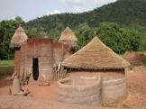
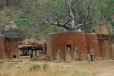
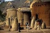
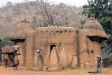
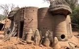
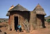
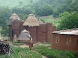
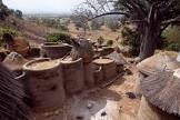
The Kutamaku landscape in northeastern Togo, which stretches into neighbouring Benin, is home to the Batamariba people, whose mud towers (Takienta) have become a symbol of Togo. In this landscape, nature is closely linked to the rituals and beliefs of society. The 50,000-hectare cultural landscape is remarkable for the architecture of its towers, which reflect the social structure, farmland and forest, and the connection between people and the landscape. Many of the buildings are two-storey high, and those with granaries are almost spherical with a cylindrical base. Some buildings have flat roofs, others have conical thatched roofs. They are clustered in villages, which also include ritual spaces, springs, rocks and sites reserved for initiation ceremonies.
| image |
http://commons.wikimedia.org/wiki/Special:FilePath/Togo%20Taberma%20house%2002.jpg |
| media legend |
Cases de Koutammakou |
| start time |
2004-01-01T00:00:00Z |
| official name |
كوتاماكو، وطن باتاماريبا |
| official name |
Koutammakou, the Land of the Batammariba |
| official name |
Kutammaku – País de los batammariba |
| official name |
Koutammakou, le pays des Batammariba |
| official name |
クタマク、バタマリバ人の土地 |
| official name |
Koutammakou – land van de Batammariba |
| official name |
Кутаммаку – земля народности батаммариба |
| official name |
古帕玛库景观 |
| volume as quantity |
World Heritage selection criterion (v) |
| volume as quantity |
World Heritage selection criterion (vi) |