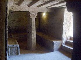
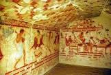
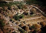
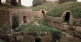
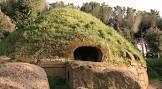
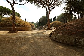
These two large Etruscan cemeteries reflect different types of burial practices from the 9th to the 1st century BC and bear witness to the achievements of Etruscan culture. Over nine centuries, the Etruscan culture developed the first urban civilization in the northern Mediterranean. Some of the tombs were large, cut into the rock and topped with impressive mounds (burial mounds). Many had carvings on the walls, and others had frescoes of excellent quality. The cemetery near Cerveteri, known as Banditaccia, contained thousands of tombs, organized according to an urban plan with streets, small squares and neighborhoods. The site contained a variety of different types of tombs: channels cut into the rock; mounds; and some tombs, also cut into the rock, in the shape of huts or houses, with rich structural details. These are the only remaining evidence of Etruscan residential architecture. The Necropolis of Tarquinia, also known as Monterozzi, contains 6,000 tombs cut into the rock. The cemetery is famous for 200 painted tombs, the earliest of which dates back to the 7th century BC.
| floruit |
Cervèteri |
| number of rooms |
lccn-n83033427 |
| topographic prominence |
11312 |
| office held by head of the organization |
http://g.co/kg/m/064p1d |
| postal code |
00052 |
| Commons category |
Cerveteri |
| licence plate code |
ROMA |
| valid in period |
standard time |
| local dialing code |
0699 |
| coordinate location |
Point(12.1 42.0) |
| named as |
Cerveteri (Itálie) |
| Italian cadastre code |
C552 |
| official website |
http://www.comune.cerveteri.rm.it/ |
| topic's main category |
Category:Cerveteri |
| page banner |
http://commons.wikimedia.org/wiki/Special:FilePath/Cerveteri-banner2.jpg |
| Dewey Decimal Classification |
2--4563 |
| coordinates of northernmost point |
Point(12.0498103 42.078465) |
| coordinates of southernmost point |
Point(12.1528412 41.9370114) |
| coordinates of easternmost point |
Point(12.2043365 42.029825) |
| coordinates of westernmost point |
Point(11.9957764 42.0566896) |
| described by source |
Paulys Realenzyklopädie der klassischen Altertumswissenschaft |
| category for people born here |
city in Chile |
| UN/LOCODE |
ITCI4 |
| elevation above sea level |
81 |
| start time |
2020-09-01T00:00:00Z |
| uses |
4089100-8 |
| image |
http://commons.wikimedia.org/wiki/Special:FilePath/Cerveteri%2C%20necropoli%20della%20banditaccia%2C%20via%20sepolcrale%20principale%2C%2002.jpg |
| instance of |
comune of Italy |
| capital |
Cerveteri |
| shares border with |
Pinos |
| shares border with |
Santa Marinella |
| shares border with |
Tolfa |
| shares border with |
Ladispoli |
| shares border with |
Nizam al-Mulk |
| end time |
2014-12-31T00:00:00Z |
| start time |
2015-01-01T00:00:00Z |
| locator map image |
http://commons.wikimedia.org/wiki/Special:FilePath/Map%20of%20comune%20of%20Cerveteri%20%28province%20of%20Rome%2C%20region%20Lazio%2C%20Italy%29.svg |
| executive body |
Cerveteri |
| date of death |
Point(11.9957764 42.0566896) |
.JPG)
.jpg)